No items here yet.
Blog
-
What is Remote ID?
As drones become part of everyday life—from filmmaking to infrastructure monitoring—Remote Identification (Remote ID) has emerged as a vital safety and accountability tool. Often called a “digital license plate,” Remote ID lets drones broadcast or transmit their identity and flight data in real time, ensuring they’re visible to airspace authorities, law enforcement, and other users.
Remote ID is now mandatory in many countries, including the United States, European Union, Japan, and others, supporting the safe integration of drones into increasingly crowded skies.
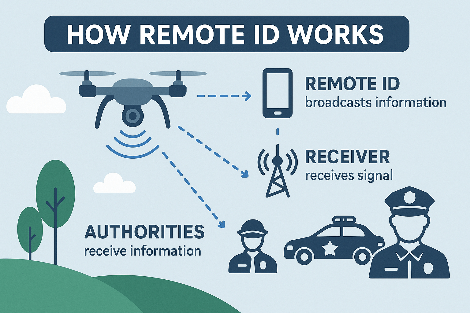
How It Works
Remote ID uses Bluetooth or Wi-Fi to send data—like drone ID, position, and controller location—to nearby receivers, accessible via smartphones or dedicated devices, with a typical range of a few 100 meters, depending on antenna location.
Who Uses Remote ID and Why
- Aviation regulators manage airspace and enforce rules.
- Law enforcement identifies drones during incidents or near restricted areas.
- Air traffic systems coordinate drones with crewed aircraft.
- Commercial operators use it for fleet tracking and compliance.
- Public safety agencies distinguish friendly drones from threats
Technology and Benefits
Remote ID integrates with systems like ADS-B, FLARM, and counter-UAS technologies, enhancing both local and national airspace awareness. It supports safe urban operations, BVLOS flights, and public trust by linking drones to responsible operators.
Conclusion
Remote ID is essential to modern drone operations. It enables safe skies, fosters accountability, and underpins the future of Urban Air Mobility and autonomous flight. As regulations mature and technologies advance, Remote ID ensures drones operate securely, visibly, and in harmony with other airspace users.
Our products for remoteID
-
What is FLARM?
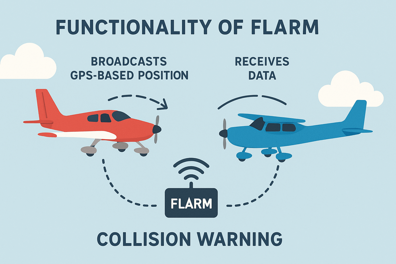
FLARM is a compact, intelligent collision avoidance and situational awareness system originally developed for gliders and light aircraft, and now widely adopted in helicopters, UAVs, and even ground vehicles in industrial environments. FLARM works by broadcasting an aircraft’s (or vehicle’s) position, velocity, and flight path over short-range radio, enabling nearby equipped units to predict potential conflicts and issue real-time alerts.
Originally designed to fill the gap left by radar and ADS-B in low-level, VFR airspace, FLARM provides a decentralized, low-cost, and privacy-conscious solution to traffic awareness and deconfliction—particularly in areas where conventional air traffic control is unavailable.
How It Works
Each FLARM unit uses GNSS (e.g., GPS) to determine position, altitude, and motion, which it then transmits over a license-free ISM band (typically 868 MHz in Europe or 915 MHz in North America). A built-in collision prediction algorithm continuously computes possible future trajectories of both the ownship and received targets, triggering audio and visual alerts if a collision risk is detected.
Key transmission data includes:
- 3D position and velocity
- Heading and rate of climb/descent
- Aircraft or asset ID (can be anonymized)
- Optional intent (planned trajectory or destination)
The communication range is typically 3–10 km, depending on antenna quality and line-of-sight.
Broader Ecosystem – Other Compatible and Competing Systems
FLARM is part of a growing ecosystem of airborne traffic awareness technologies, many of which use different protocols and frequencies. Some of these systems are partially or fully interoperable with FLARM, while others require integration via ground relays or bridging devices:
- PilotAware: A UK-developed system aimed at general aviation. It detects and broadcasts over both FLARM and ADS-B frequencies, and can bridge multiple traffic formats including Mode S and FLARM, increasing awareness of nearby non-cooperative targets via ground stations.
- ADS-L (Airborne Dependent Surveillance – Local): An emerging EASA standard designed for low-cost electronic conspicuity, particularly for drones and light aircraft. ADS-L supports encrypted broadcasts and is expected to be compatible with certain FLARM-based systems under a harmonized framework.
- OGN (Open Glider Network): A community-driven network that aggregates live FLARM, FANet, and other telemetry data via a network of ground receivers. OGN tracks aircraft in real time and provides online visibility through platforms like LiveTrack24 and GliderNet. While FLARM data is integrated, full protocol-level compatibility depends on device configuration.
- FANet (Flying Ad-Hoc Network): A lightweight broadcast system developed for paragliders, hang gliders, and drones. It uses similar frequencies and packet structures to FLARM but with different protocols. FANet devices can sometimes be integrated with FLARM via dual-protocol transceivers or OGN bridges.
Together, these systems form a diverse ecosystem aimed at increasing electronic conspicuity and airspace safety for all types of low-level aviation.
Beyond Aviation – FLARM in Industrial Tracking
FLARM is not limited to aircraft. In recent years, it has been successfully adopted for ground-based asset tracking in mining, logistics, and construction. For example, ore trucks in copper mines use FLARM to broadcast their positions and receive alerts from nearby vehicles, reducing collision risk in dust-filled or visually obstructed environments. The same benefits apply to bulldozers, forklifts, and other heavy equipment operating in dynamic, high-risk areas.
Conclusion
FLARM provides an effective, decentralized solution for real-time collision avoidance, situational awareness, and asset tracking—both in the air and on the ground. While alternative systems like PilotAware, ADS-L, OGN, and FANet offer overlapping functionality, they often target specific user groups or regulatory frameworks. Whether integrated natively or bridged via ground networks, FLARM remains a cornerstone technology for safe operation in complex, radar-free environments.d technologies, we recognize the significant contribution of FLARM to enhancing flight safety.
Our products for FLARM
-
What is AIS?
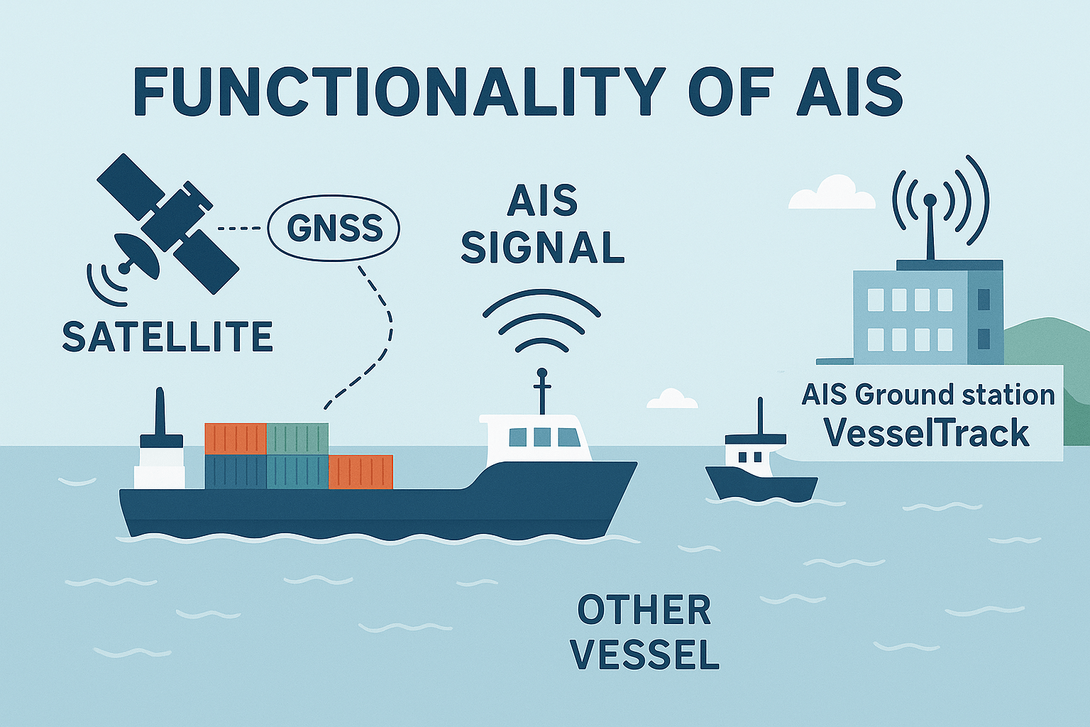
The Automatic Identification System (AIS) is a standardized maritime communication system that enables vessels to automatically broadcast critical information such as identity, position, course, and speed over VHF radio. Originally developed for collision avoidance, AIS has become a central pillar of maritime safety, navigation, and operational oversight.
The International Maritime Organization (IMO) mandates AIS carriage for:
- All passenger ships
- All commercial vessels ≥300 gross tonnage on international voyages
- Cargo ships ≥500 gross tonnage on domestic voyages
Smaller and recreational vessels may carry Class B AIS, which operates at lower transmission power and with reduced update rates.
How AIS Works – Technical Overview
AIS operates on VHF maritime channels (161.975 MHz and 162.025 MHz), using GMSK modulation and a 9.6 kbps data rate. Two main types of AIS transceivers exist:
- Class A (required for large vessels): Uses SOTDMA, transmits every 2–10 seconds while moving.
- Class B (optional for smaller vessels): Uses CSTDMA, transmits every 30 seconds to 3 minutes.
Each transmission includes standardized messages covering:
- Static data: MMSI, ship name, call sign, vessel type
- Dynamic data: Position, speed, course, heading
- Voyage data: ETA, draft, destination
- Binary messages: Alerts, weather reports, Aids-to-Navigation (AtoN) info
Transmission range typically spans 20–40 nautical miles via line-of-sight VHF, and can extend globally through Satellite AIS (S-AIS).
Who Uses AIS Data – And Why
AIS data is invaluable to a wide array of users across the public, private, and defense sectors:
- Commercial Vessels and Ship Captains use AIS to improve navigational safety, especially in crowded sea lanes or poor visibility. Real-time awareness of nearby ships helps prevent collisions and reduces reliance on radar alone.
- Port Authorities and Vessel Traffic Services (VTS) rely on AIS to monitor ship movements, manage docking schedules, and optimize port operations. By tracking vessels approaching and leaving ports, they can reduce congestion and improve turnaround times.
- Coast Guards, Border Agencies, and Navies use AIS for maritime surveillance, search and rescue coordination, and maritime security enforcement. Knowing the real-time position and identity of vessels aids in detecting suspicious behavior and responding quickly to emergencies.
- Fleet Operators and Shipping Companies monitor AIS data to manage logistics, plan routes, optimize fuel use, and analyze vessel performance. AIS-based analytics also support predictive maintenance and supply chain coordination.
- Environmental Agencies and Researchers use AIS to study maritime traffic patterns, assess the impact on marine ecosystems, and monitor activity in protected or restricted zones.
- Insurance Companies and Investigators analyze AIS records post-incident to reconstruct maritime accidents, verify claims, and evaluate liability.
The Strategic Role of Industrial and Defense AIS Ground Stations
While satellite AIS enables global coverage, terrestrial AIS ground stations—especially those designed for industrial or defense applications—offer key advantages:
- High-Resolution Data: Ground stations can receive AIS signals with higher fidelity, frequency, and spatial accuracy compared to satellite downlinks. This is critical for time-sensitive decisions near coasts, harbors, and strategic chokepoints.
- Low Latency: Terrestrial stations provide real-time or near-real-time data without relying on orbital passes, ensuring instant situational awareness for dynamic environments like port approaches, conflict zones, or exclusive economic zones (EEZs).
- Data Control and Security: Defense-grade AIS infrastructure ensures that data remains within secure networks, protecting sensitive movement patterns of naval and commercial vessels from interception or manipulation.
- Integration with Radar and Sensors: Industrial ground stations can be co-located with radar, cameras, and other maritime sensors, creating a fused picture of vessel activity that is more complete and reliable.
- Critical Infrastructure Monitoring: Governments and private operators use AIS ground stations to monitor traffic around oil platforms, undersea cables, naval bases, and shipping lanes, where precision and control are paramount.
Conclusion
AIS is far more than a collision avoidance tool—it is a vital component of global maritime infrastructure. From enabling safe navigation and port efficiency to empowering defense and intelligence operations, AIS serves diverse strategic needs. When paired with industrial or defense-grade ground stations, the system delivers unparalleled value in real-time situational awareness, maritime security, and national sovereignty.
Our products for AIS
- All passenger ships
-
What is ADS-B?
Understanding Automatic Dependent Surveillance–Broadcast (ADS-B): A Foundational Technology in Modern Aviation
In the sphere of modern aviation, precision, safety, and efficiency are paramount. A cornerstone technology enabling advancements in these areas is Automatic Dependent Surveillance–Broadcast, commonly known as ADS-B.
Defining ADS-B: A Technical Overview
ADS-B is an advanced surveillance technology that allows aircraft to automatically transmit flight information without pilot or controller intervention. The acronym itself provides a concise summary of its function:
- Automatic: The system operates autonomously, requiring no manual input from the flight crew for its primary surveillance function.
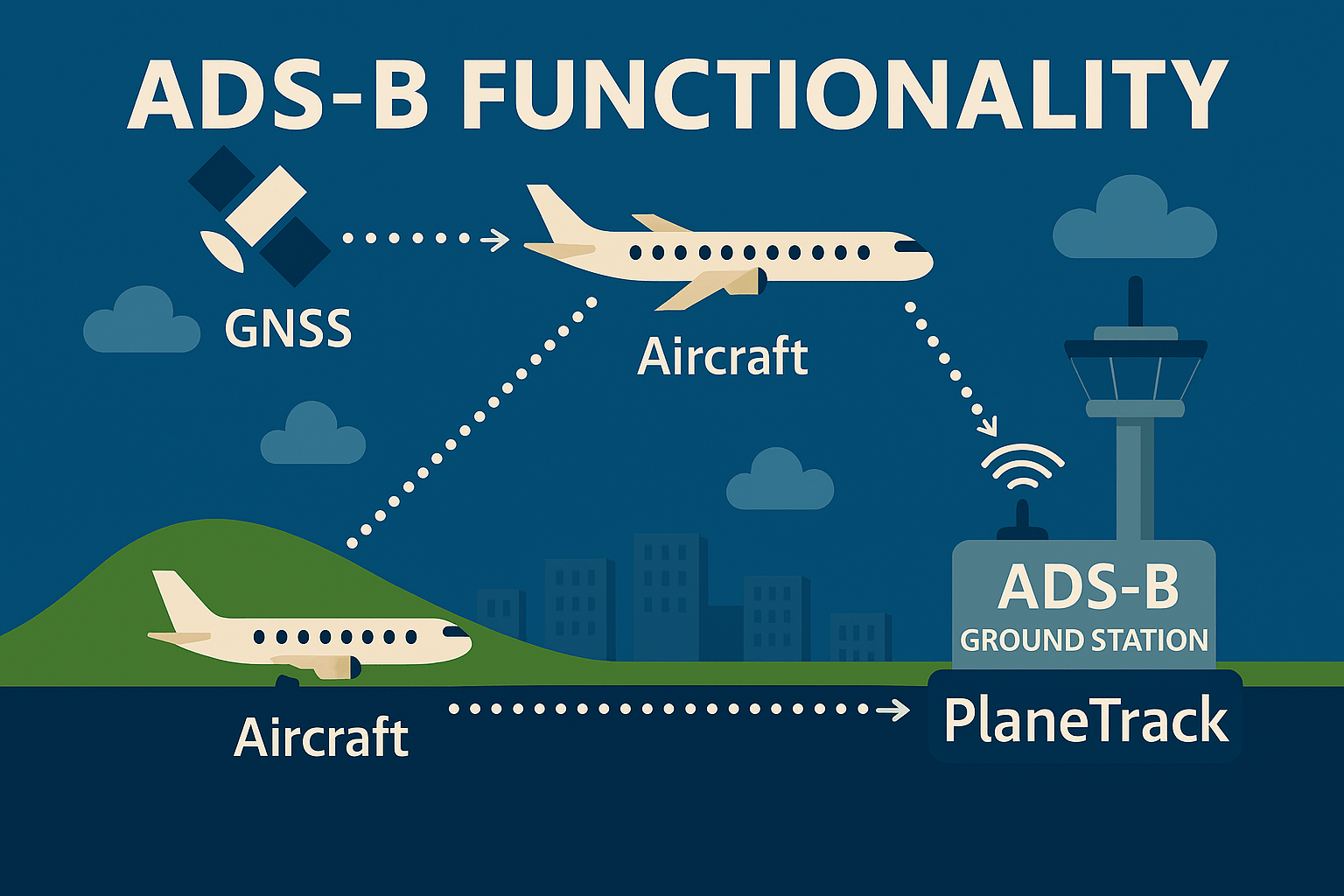
- Dependent: The accuracy of the broadcast data relies on the aircraft’s own navigation systems, principally the Global Navigation Satellite System (GNSS), such as GPS, to determine its precise position.
- Surveillance: It provides a method of observing and tracking aircraft, replacing or augmenting traditional radar systems.
- Broadcast: Aircraft periodically transmit their data (including identity, GNSS-derived position, altitude, velocity, and other parameters) to any suitably equipped receivers.
This broadcast information is accessible to Air Traffic Control (ATC) ground infrastructure, and dedicated ADS-B receiving units, industrial and defense ground stations and other interested users.
Operational Mechanics of ADS-B
Aircraft equipped with an “ADS-B Out” transponder utilize their onboard GNSS receiver to ascertain their precise geographical coordinates. This positional data, along with other vital flight parameters, is then typically broadcast once per second via a digital data link, commonly on the 1090 MHz frequency (known as 1090ES or 1090 MHz Extended Squitter).
The system comprises two main components:
- ADS-B Out: This refers to the aircraft’s capability to transmit its state vector (position, velocity, etc.) and other information. Regulatory bodies worldwide have increasingly mandated ADS-B Out equipage for aircraft operating within designated airspaces, recognizing its significant contribution to air traffic visibility and accuracy.
- ADS-B In: This is the complementary capability to receive ADS-B data transmitted by other aircraft. For pilots, ADS-B In provides enhanced situational awareness through cockpit displays of traffic information (CDTI). It can also deliver Flight Information Services-Broadcast (FIS-B) – such as weather products – and Traffic Information Services-Broadcast (TIS-B), which rebroadcasts radar data for non-ADS-B equipped aircraft.
The Significance of ADS-B in Aviation
The implementation and adoption of ADS-B technology deliver substantial benefits across the aviation spectrum:
- Improved Situational Awareness: Both flight crews and air traffic controllers benefit from a more comprehensive and real-time depiction of the air traffic environment.
- Extended Surveillance Coverage: ADS-B facilitates surveillance in regions where traditional radar deployment is impractical or cost-prohibitive, including oceanic, mountainous, and remote terrestrial areas.
- Cost-Effectiveness: The ground infrastructure for ADS-B can be less expensive to install and maintain compared to primary and secondary surveillance radar systems.
- Data Accessibility: Beyond operational ATC use, ADS-B data is accessible to airlines for operational monitoring and other interested parties via special ground stations.
As a provider of ADS-B receiving solutions, we recognize the advanced role this technology plays. Our devices empower users to connect directly with this stream of aviation data, offering unique insights into the complex and dynamic nature of air traffic.
We encourage you to explore our range of ADS-B receivers and delve deeper into the capabilities this transformative technology offers.
Our products for ADS-B